From the earliest civilisations, people have needed to measure the land and set out areas for farming and buildings. The best way to present this information is on a map. The process of making or drawing maps is called cartography.
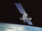
The first step in creating a map is collecting geospatial data. Today surveyors and other spatial professionals do this work.
Surveyors are experts in the science of measurement: they collect and use spatial information. Surveyors specialise in collecting and using different sorts of geospatial data for a range of different locations:
- the land (topographical surveying) for example produce a map showing how steep a piece of land is to help an engineer design a building
- property boundaries (cadastral surveying) for example to find out how much land someone owns
- structures (engineering surveying) for example help map and plan new structures such as buildings, roads and bridges
- the shape of the Earth (geodetic surveying) for example collect information about global changes such as plate movement and sea level
- underwater (hydrographic surveying) for example collect information about the bottom of the sea, harbours, rivers and lakes
- mining (mine surveying) for example collect information on the surface and underground before and during the construction of mines
Once accurate geospatial data has been collected and processed by surveyors, it can be made available in many forms:
- topographical maps showing the surface of the Earth with natural and man-made features e.g. rivers, mountains, roads, buildings
- specialised maps on almost any theme e.g. water and sewage pipes, property boundaries
- plans e.g. subdivision plans
- nautical charts showing location of reefs, coast lines, tides and depths
What tools do surveyors use?
 Surveyors use special tools to help them measure. As late as the 1990s, the basic tools used by surveyors were:
- a tape measure, or steel chain for determining shorter distances
- a laser for determining longer distances and scanning for 3D mapping
- a level to determine height or elevation differences
- a theodolite set on a tripod to measure angles (horizontal and vertical)
- calculations using trigonometry
More recently laser scanning has been used for 3D mapping and theodolites are now electronic and are called 'total stations'.
Intersection or triangulation – real life use of geometry
Surveyors use a technique called intersection (which can also be called triangulation) to calculate the distance to a remote point. Intersection uses a triangle and some simple mathematics. You can use intersection to measure the distance across a river. Here’s how:

The baseline is the distance between two points A and B. For a closer object, the angles a and b will be smaller but for an object further away the angles will be larger (closer to 90 degrees). Once the angles are measured you can calculate the perpendicular distance (yellow line) to the object.

The triangle has one side with a known distance and two known angles. The distance to the object can be fixed with a simple maths equation using the two angles (a and b) and the baseline distance.
 on a tripod. Image: LEARNZ.")