Latitude and Longitude
These imaginary lines run around the earth. They help to show where we are.
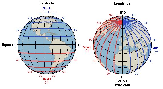
 Latitude: These are the lines that run across the globe. The latitude that runs through the middle of the Earth is given the number zero degrees (0°) and is called the equator. The latitude line at the north and south poles is given the number 90°.
Longitude: These vertical (up and down) lines around the earth meet at the poles and are widest apart at the equator.
Every point on the Earth has its own latitude and longitude ‘coordinates’. You can use this website to find your latitude and longitude coordinates.
Making Maps
The Earth is round so making a map of part of the Earth on a flat piece of paper is rather tricky. Think of peeling an orange. The peel is like a map when flattened out.

Flattening out the orange peel is like drawing the surface of the Earth on paper. This process is called ‘map projection’. A map projection is used to draw all or part of the round Earth on a flat surface. All map projections distort the surface in some way. There are different types of map projections. This is an interrupted mape projection:

Can you find out more about what type of map projections there are?