Navigation
Finding your way in the air involves the same steps as finding your way on land. These steps include:
- Planning a route
- Recording progress on that route
- Controlling movement from one point to another.
Air navigation
To find your way in the air your aircraft must;
- be flown from place to place without getting lost
- not break any of the aircraft laws
- ensure the safety of those on board and on the ground.
Air navigation is different from ground navigation because:
- Aircraft travel at high speeds, leaving less time to work out their position on route.
- Aircraft can't stop in mid-air to work out their position.
- Aircraft can only carry a set amount of fuel and usually cannot re-fuel in the air (unlike a car that can stop and refuel).
How pilots navigate depends on whether they are flying under visual flight rules (VFR) or instrument flight rules (IFR).
Visual Flight Rules VFR
VFR means that a pilot can see outside the cockpit, so they can control the aircraft's height, navigate, and avoid aircraft and other obstacles. There are set limits that state how far the pilot must be able to see and the distance they need to be away from clouds. A pilot flying under  Visual Flight Rules will use;
- what they can see
- calculations based on speed and time to work out the distance travelled (Distance = Speed x Time).
- reference to charts and other navigational aids such as GPS and radio navigation aids.
An aircraft flying at 250 knots airspeed for two hours has flown 500 nautical miles through the air.
Instrument Flight Rules IFR
If a pilot is flying with IFR they are using instruments (including GPS), radio navigation aids such as beacons, or as directed under radar control by air traffic control.
Aeronautical charts
A pilot uses aeronautical charts to plan a flight path or track. These charts are maps that show features about which a pilot needs to know. These charts include the following information;
- controlled airspace
- radio navigation aids
- airfields
- hazards to flying such as mountains, tall radio masts, etc.
- ground detail - towns, roads, wooded areas - to help with visual navigation.
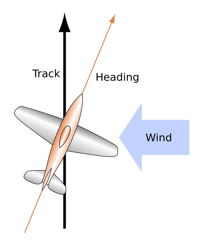
When an aircraft is in flight, it is affected by the wind so maintaining an accurate ground track is not so easy. The pilot must adjust its heading to take into account the wind, so they can follow the ground track. You can see this in the image on the right.

