Everybody and everything is somewhere. The ‘where’ is a location on the ground. A map shows where things on the ground are. Everyday we use and collect information about where things are; this information is called geospatial data.
We all have some understanding of where we are. When you close your eyes you can imagine where you are. For example, with your eyes closed you can point to the door you used to enter the room you are in. You might be able to point to where you live or where your school is. We all hold pictures in our heads that help us decide how to move across the school grounds, or travel home. These pictures are based on past experiences.
Information about where things are located is called location-based information or geospatial data.
What does geospatial data mean? 
- geo – meaning the earth
- spatial – meaning space (the space around us)
- data – means a group of facts for example numbers, words, measurements or records of what we see
How do I know where I am?
Since the time of cavemen humans have needed to know where they are and where to go to find food and shelter. People have been drawing pictures to show where things are for a very long time. The Babylonians drew maps on clay tablets over 4,000 years ago. Now technology is making this process much easier.
How do you use technology to help you know where you are?
Māori oral maps
Māori had been living in New Zealand for at least 300 years before Abel Tasman arrived in 1642. They had named every feature of the land, forming an oral map, often told as a kōrero or whakapapa. In some cases posts or piles of rocks were used to mark boundaries. Māori did not draw maps.
Making maps
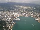
Information or data for making maps was first collected by people who recorded what they saw on the Earth’s surface. These people were often sailors or explorers. People who have the job of making accurate measurements of the surface of the Earth so we can make maps are called surveyors. These days aerial photos and satellites give us very accurate data about the surface of the Earth.


Comments
I wonder if fewer printed maps are being made and sold
What materials do people use
Maps
I wonder how the Babylonians