You can contact LEARNZ, part of CORE Education, at:
Postal Address:
PO Box 13 678,
Christchurch 8141,
New Zealand

Earthquakes happen every day in New Zealand. Over 14 000 earthquakes are recorded each year. Most are too small to notice, but between 150 and 200 are big enough to feel. Earthquakes happen most often where two moving plates meet and press against each other.
New Zealand has many earthquakes because it is on the boundary between the Pacific Plate and the Australian Plate. Stresses cause cracks, called faults, in the Earth's crust. Earthquakes usually occur along faults because these areas are weak and can move.
The biggest earthquake to have occurred in New Zealand since European settlement was in the Wairarapa in 1855. It was a magnitude 8.2 earthquake. Areas of land moved sideways up to 18 metres and some areas were pushed up as much as six metres.
The 2010 Canterbury earthquake happened on the Greendale fault. The land shifted across by four metres in some places and in other areas land was pushed up by one metre. The February 2011 Christchurch earthquake occurred on the Port Hills fault, which is close to the city. The Greendale fault was unknown before the earthquake in 2010.
On 14 November 2016, a magnitude 7.8 earthquake, the second strongest quake since European settlement, shook the eastern coast of the northern South Island. Lasting for nearly two minutes, the complex earthquake started near Culverden, then moved north-east, jumping between at least 21 faults, both onshore and offshore, along 180 kilometres of the Marlborough coast. The shaking caused thousands of landslides, closing roads and rail links. The quake caused damage to buildings in Kaikōura, surrounding towns and Wellington.

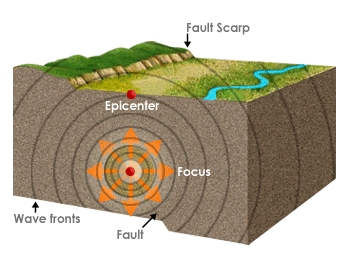
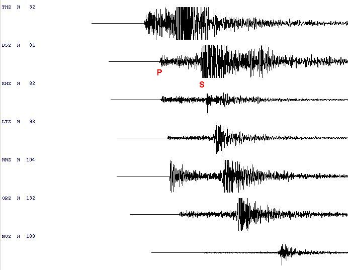
The place underground where a fault ruptures is called the focus, and the point directly above on the Earth’s surface is called the epicentre. The energy released by a fault movement spreads outwards as seismic waves.
Earthquakes create two types of seismic wave:
Major earthquakes in Aotearoa
| Place | Date | Magnitude |
| Kaikōura | 2016 | 7.8 |
| Cook Strait and Lake Grassmere | 2013 | 6.5 and 6.6 |
| Canterbury | 2010 and 2011 | 7.1 and 6.3 |
| Fiordland | 2009 | 7.8 |
| Edgecumbe | 1987 | 6.3 |
| Inangahua | 1968 | 7.1 |
| Napier - Hawkes Bay | 1931 | 7.8 |
| Murchison - Buller | 1929 | 7.8 |
| Wairarapa | 1855 | 8.2 |

 For hundreds of years before Europeans arrived, Māori had felt rū whenua. Rū whenua means ‘the shaking of the land’.
According to Māori tradition, earthquakes are caused by the god Rūaumoko, the son of Ranginui (the Sky) and his wife Papatūānuku (the Earth). Rūaumoko is the god of earthquakes and volcanoes. Rūaumoko causes earthquakes as he walks about.
Ready for a quiz? Try the Earthquakes in Aotearoa interactive activity.
Rangi had been separated from Papa, and his tears had flooded the land. Their sons tried to turn their mother face down, so that she and Rangi would not see one another’s sorrow. When Papatūānuku was turned over, Rūaumoko was still at her side and was carried to the world below. To keep him warm he was given fire. He is the god of earthquakes and volcanoes, and the rumblings of the land are made by him as he walks about.
Several accounts of earthquakes felt by Māori have been described. They include two large earthquakes, at Taupō and Rotorua. It was said that at Rotorua a pā, with about 1,000 people, was swallowed up and the area became a lake. Māori also spoke of two earthquakes along the Whanganui River in the 1830s.